civpy.survey.SpatialHash
-
class
civpy.survey.SpatialHash(points, grid)[source]¶ A class representing a spatial hash structure for efficient distance queries.
Parameters: - points : list
A list of points of shape (N, D).
- grid : float
The width of each spatial hash grid element. For 2D spaces, this value represents the width and height of each square spatial hash partition.
Examples
The below example uses the
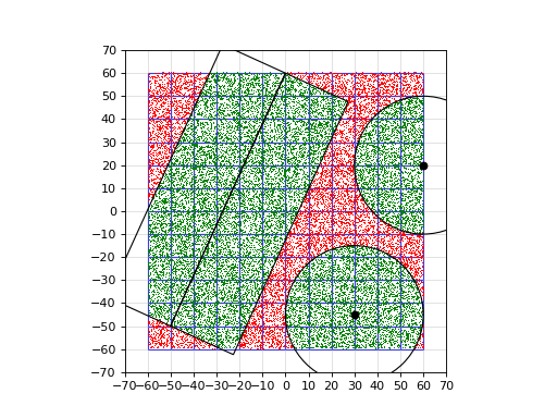
query_point()andquery_range()methods to search for points within the specified offset of a point and within the specified offset of a range, respectively. The found points are shown in green.# spatial_hash_ex2.py import numpy as np from civpy.survey import SpatialHash from matplotlib.patches import Rectangle, Circle r = 30 # Query radius np.random.seed(32874393) x = np.random.uniform(-60, 60, (30000, 2)) s = SpatialHash(x, 10) ax = s.plot(symbols=dict(points='r,')) # Find points within radius of points points = np.array([ (30, -45), (60, 20) ]) # Plot query points ax.plot(points[:,0], points[:,1], 'ko', zorder=10) for p in points: # Plot found points i = s.query_point(p, r) xp = s.points[i] ax.plot(xp[:,0], xp[:,1], 'g,', zorder=5) # Plot circle circ = Circle(p, r, color='k', fill=False, zorder=10) ax.add_artist(circ) # Find points within offset of range ranges = np.array([ [(-50, -50), (0, 60)] ]) for a, b in ranges: # Plot found points i = s.query_range(a, b, r) xp = s.points[i] ax.plot(xp[:,0], xp[:,1], 'g,') # Plot rectangles dx, dy = b - a c = np.linalg.norm(b - a) ang = np.arctan2(dy, dx) * 180/np.pi rect = Rectangle(a, c, r, angle=ang, color='k', fill=False, zorder=10) ax.add_artist(rect) rect = Rectangle(b, c, r, angle=ang+180, color='k', fill=False, zorder=10) ax.add_artist(rect)
(Source code, png, hires.png, pdf)
Methods
get(self, point[, norm])Returns the point indices correesponding to the same hash as the input point. multi_get(self, points[, norm])Returns the point indices corresponding to the input array of points. plot(self[, ax, symbols])Creates a plot of the spatial hash. query_point(self, point, ro[, ri])Returns an array of point indices for all points contained within the specified inner and outer radii from the input point. query_range(self, a, b, ro[, ri])Returns an array of point indices for all points along the specified range within the inner and outer offsets.